


Introduction
The evolution of alluvial systems is controlled mainly by general geological conditions of the watershed, regional tectonic regime, and by general hydrological and climatic conditions leading to a specific local weathering regime, stream network density, fluctuations and transport capacity of the stream. The presence of a compressible substratum beneath active alluvial systems is a very specific factor influencing the alluvial style, often being of critical importance. It is usually studied in modern environments (e.g., Brain et al., 2017; Bruno et al., 2019; Stouthamer & Van Asselen, 2015; Van Asselen, 2011; Van Asselen et al., 2009, 2010) but not so frequently interpreted within older geological units like those of Lower Miocene age (Mach, 2002; Rajchl & Uličný, 2005). Compressible materials are represented by salt, uncompacted clays or peat (Cohen & Hardy, 1996; Rajchl & Uličný, 2005).
The authors of this paper had a long-lasting opportunity to observe the architectures of ancient alluvial systems affected by soft substrata in huge open-cast lignite mines in the Miocene Most Basin. In this case, very thick layers of peat functioned as the compressible substratum in Miocene times, now having the form of coal seams. The thickness of the Miocene peat layers in the Most Basin was one order of magnitude higher than known from modern peatlands. Still, the interpretation of the observed phenomena in the Miocene formations would not be possible without looking for an analogue in modern systems. Many active peatlands related to active alluvial systems can be observed in the world. The thicknesses of peat layers accompanying modern alluvial systems usually do not exceed 10 m (e.g., Crezee et al., 2022; K. Koster et al., 2017). Such peat thicknesses have usually built up during the last 6–10 ky, since the last global glaciation, and peat formation in these systems is still in progress.
Many Holocene alluvial systems were affected by the compaction of underlying peat (e.g., Törnqvist, Wallace, et al., 2008; Van Asselen, 2011; Van Asselen et al., 2009). Peat compaction locally generates additional accommodation space for clastic material transported by the rivers. It usually occurs immediately after loading, with recently observed rates of 3–6 mm/yr depending on organic-matter contents and the weight of sediment overburden (Van Asselen et al., 2010). Research from recent bogs proved a more pronounced compaction beneath the river bed sediments than in the open area of the bog. The highest rates of compaction by such loading are estimated to occur during the first centuries of loading (Stouthamer & Van Asselen, 2015).
Most of the published Holocene peatbog–alluvial system interactions seem to bear no parallel with the conditions governing early Miocene sedimentation in the Most Basin. Here, under conditions of a subsiding bottom of the rift basin, the thicknesses of partly compacted peat could have exceeded 100–200 m (Hurník, 1972; Mach, 2002). This led not only to more intensive compaction of peat under the load of younger clastic sediments but also to exceptionally intensive sedimentation of clastic deposits on top of the peat layer and also to frequent large-scale synsedimentary deformations of alluvial sediments and the peat layer (e.g., Mach, 2002). The coal seam within the Most Basin is locally split into several levels by clastic sediments of alluvial systems, which means that the compaction/deformation effects are often observed. They depend, among other factors, on the thickness and properties of the underlying peat. At present, many examples of these effects are well exposed in the faces of huge open-cast coal mines. Coals in the Most Basin are considered, in terms of international coal classification terminology, to be transitional between lignite and subbituminous coal. For the purpose of this paper, we will be using the term coal.
Extensive data sources (boreholes, mines) allow us to discuss the processes taking place in settings where high thicknesses of peat interact with alluvial systems. Most previous papers on peat compaction deal with relatively low peat thicknesses, often known only from boreholes and surface observations. Our research is based on knowledge from the environment of enormous peat thicknesses (over 100 m) perfectly exposed by coal mining.
Geological background
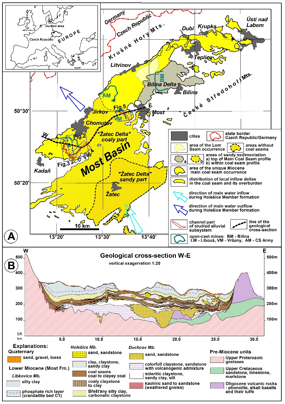
The Most Basin (Fig. 1) is the largest sedimentary basin within the Ohře Rift structure of Oligocene–Miocene age (Rajchl et al., 2009), located in the NW part of the Bohemian Massif (Czech Republic). The fabric of basin floor consists of Proterozoic gneisses, Carboniferous and Cretaceous sediments. Basin history started with the deposition of lavas and volcaniclastics and redeposition of their weathering products in the Oligocene (Střezov Formation). Accumulation and erosion of this unit was controlled by E–W-striking faults during a N–S-orientated extension (Rajchl et al., 2009). After a decrease in volcanic activity during the continued basin-floor subsidence, the basin was filled with the main volume of organic and siliciclastic material (Miocene Most Formation).
_at_the_stratigraphic_level_of_the_main_co.jpeg)
The lower part of the Most Formation (Duchcov Member) is represented by transitional sediments between locally weathered volcanogenic material and siliciclastics transported by the Central River from the southwestern part of the Bohemian Massif (Mach et al., 2014). The following unit, the Holešice Member (Fig. 1), is the main stratigraphic object of this study. It is represented by a widespread coal seam (Main Coal Seam) with an average thickness of about 30 m and accompanying variegated clastic sediments prevalently of fluvial, deltaic and lacustrine origin. Depending on local conditions, the Main Coal Seam is split into a number of stratigraphic subunits (Supplementary material I) by sheet-like bodies of siliciclastic sediments pertaining to the Central River alluvial system (Mach et al., 2014). The interaction between the widespread peat swamp and the developing alluvial systems of the Central River resulted in the formation of the Žatec Delta siliciclastic body in the western part of the Most Basin (Fig. 1). Near the end of the lifetime of peat-accumulation conditions, the Central River shifted to the Bílina area, where the lacustrine Bílina Delta was formed in the peat layer overburden as a result of this avulsion (Rajchl et al., 2008). Probably faster subsidence of the basin finally led to a flooding of the whole peat bog area and changed swampy conditions into lacustrine ones (Libkovice Member), where up to 200 m of clays and silts were deposited. The area of the Bílina Delta is a classic place where prominent synsedimentary deformations of delta bodies and coal seams were repeatedly described (Hurník, 1982; Mach, 2002). Many authors tried to solve this phenomenon but only Mach (2002) interpreted synsedimentary deformations of the sediments as a result of uneven loading of compactible peat by clastic bodies. Uneven loading of the peat layer led to the development of growth faults and to sinking of deltaic sediments to, and sometimes even below, the level of the peat layer/coal seam. Mach (2002) and Hurník (1972) also tried to calculate the compression of peat to the present coal in the Bílina area. Results of both authors show the compaction ratios of 1:7 to 1:10 for coal with low ash content and 1:5 for clayey coal.
“Žatec Delta”
The term Žatec Delta usually denotes a large siliciclastic/organic matter body covering almost the whole western part of the Most Basin. The first intensive studies of these sediments relate mainly to core drilling during coal exploration (e.g., Brus, 1982; Hurník, 1978). Later on, many authors used heavy minerals from the sand-dominated sediments for palaeogeographical reconstructions (Čadek, 1966; Elznic et al., 1998; Mach et al., 2014). Unfortunately, only two local sedimentological studies were performed (Novotný & Mach, 2016; Rajchl & Uličný, 2005), although the sediments are well exposed in the large open-cast mines of Vršany and Libouš.
The term Žatec Delta does not imply a true delta in the sense of a clastic body at the border of a lacustrine sedimentary basin. Instead, it represents a complex of alluvial sediments generated within the peatbog by a long-lasting fluvial system activity (Rajchl & Uličný, 2005). The Central River is considered as the main source of water and detrital material for this clastic body. Frequent avulsions of this fluvial system in time and space are the reason for intensive coal seam splitting of various intensity and shape in various areas of the western part of the Most Basin. Individual sedimentary bodies formed by avulsions of the alluvial system were named by their typical localities (Novotný & Mach, 2016) and usually consist of the main fluvial belt (stratified sand, silt) bordered by overbank fines (Supplementary material I). Such clastic bodies, having the form of wide tongues splitting the coal seam usually reach hundreds of metres in width and up to tens of kilometres in downstream axis with an average thickness of 1–X0 metres. Alluvial sediments completely prevail close to the inflow of the Central River into the basin (Žatec town vicinity). There, an accumulation of siliciclastic sediments up to 250 m thick occurs over the area of more than 100 square kilometres. Farther from this inflow point to the north, northwest and northeast, the proportion of coal beds in the sedimentary formation gradually increases until they finally gain prevalence (Chomutov and Most area). One of the partial alluvial systems of the eastern part of the Žatec Delta called Hrabák was described by Rajchl and Uličný (2005) from the Most area (Vršany Mine). This alluvial system belongs to the Holešice stage of the Main Coal Seam development (the term Hrabák–Holešice alluvial system/stage is used in the text below). The authors observed a gradual synsedimentary compaction of the underlying peat due to loading by clastic sediments, which caused repeated local avulsions of the river. A few similar clastic bodies exposed in the Libouš Mine were found in the opposite, western border part of the Žatec Delta by drilling exploration and by documentation of mining activities. The oldest one, positioned in the lowermost part of the Main Coal Seam, represents a rather large fluvial plain. Another two alluvial systems represent typical tongue-like elongated clastic bodies enclosed within the coal seam (Novotný & Mach, 2016). The perfect exposure by the open-cast mines gives a good opportunity to describe the effects of peat compaction on the formation of alluvial sediments and vice versa.
Methods
Vast exposures in the open-cast mines were graphically and photographically documented with the focus on the main architecture of the alluvial systems. Coal and overburden faces in the Vršany Mine were documented in years 2014–2022. In the case of the Libouš Mine, the architecture of the clastic bodies was reinterpreted from older photos because the Libouš alluvial system was completely excavated before 2013, when the present authors started their research here. We also focused on tectonic elements, especially faults, flexures, etc., measuring these structures by a geological compass. Moreover, the dense exploration drill-core coverage allowed for 3D modelling of the basic sedimentary bodies of these alluvial systems. At the two localities (Vršany/Hrabák Mine and Libouš Mine), more than 3000 boreholes were processed using special software Atlas DMT. Lithological descriptions of each borehole were digitized to display their sections in graphic programmes. Coal analyses (ash content in the coal seam) were also very useful for correct correlations of the individual strata. 3D models of the bodies were created by interpolation between individual boreholes based on a triangular mesh. Most of these boreholes are managed by the mining company of Severočeské doly a.s., some of them are stored in a publicly accessible institution – the Czech Geological Survey (Geofond). Detailed 3D models of basic lithologies revealed variations in the thickness of every bed. This is important for the understanding of the compaction/loading history. Data for the construction of the dependence of compaction on the thickness and composition of the underlying peat were also obtained from boreholes (thicknesses of coal beds and ash contents in the coal). Data on the composition of peat/coal beneath the alluvial systems were determined in laboratories for the needs of mining companies. Sampling in the boreholes was performed depending on petrographic types, with the sampling interval of no less than one metre. The overall compositions of the coal seams beneath the alluvial systems were calculated as the weighted averages of all sampled segments.
Results
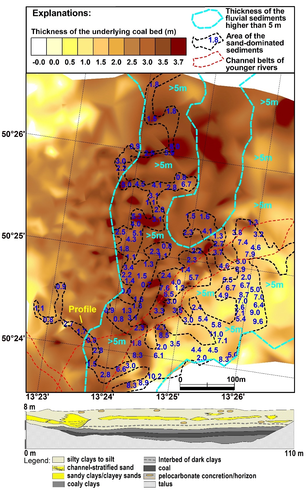
The “Březno–Droužkovice” alluvial system in the Libouš Mine area
The lowermost part of the Holešice Member is characterized by gradual spreading of the peat bog over clastic sedimentation, except of the nearest input of Central River and its alluvial systems (Mach et al., 2014). The alluvial system in the basal part of the seam differs from the younger ones in the coal seam in its widespread flood basin with many active river channels (Fig. 2). This is the case just below the mined Main Coal Seam at the Libouš Mine in the western part of the Žatec Delta area. This system is considered to be one of the oldest stages of migration of the Central River across the Most Basin, belonging to the Březno–Droužkovice stage of the Žatec Delta formation. A detailed documentation in drainage ditches of the Libouš Mine (Fig. 2) showed that the individual channels were located at the same level, corresponding to the anastomosing river style (Makaske, 2001). This whole anastomosing alluvial system rests on a bed of coaly clays and clayey coal 1-2 m thick. The content of ash in this coal is generally about 50 % and the presumed total compaction is similar to that of clayey coal beds in the Bílina area (Mach, 2002) – about 1:5. We consider it similar in the areas of our described alluvial systems. The deeper underlying sediments consist of clays, silts and marginal sands formed by the oldest stage of the Central River and local sediment sources. We do not suppose any considerable compaction potential of this interval due to its silt- and sand-dominated lithology. The parameters are summarized in Tab. 1.

The “Libouš” alluvial system
The Libouš alluvial system, described by Novotný and Mach (2016), lies within the lower part of the Main Coal Seam in the Libouš Mine area. This system was completely exposed by coal mining, thus providing a great chance for study (Fig. 3). The system represents an elongated silt-sand-clay body enclosed in a coal seam, with a lenticular shape in cross section (Fig. 3). The parameters of the alluvial system are summarized in Table 1. On its sides, the channel belt is often accompanied by fault planes parallel to the axis of the channel.
_geological_model_of_the_libou_alluvial_system_showing_the_thickness_of_the_channel_fill.jpeg)
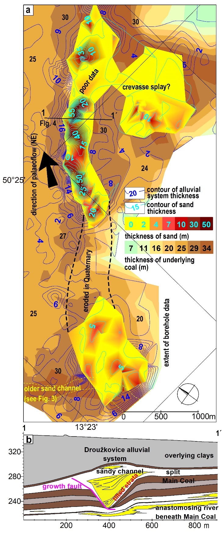
The “Droužkovice” alluvial system
Another alluvial system formed by the avulsion of the Central River affected the Libouš Mine area during peat formation again in the upper part of the Main Coal Seam. It is very similar to the above described Libouš alluvial system in its size and elongated shape, see Tab. 1 for all parameters. The course of the Droužkovice alluvial system (Fig. 4) is interrupted by two erosional windows. The first one lies in the southern part of the Libouš Mine and the second between the Libouš Mine and the Nechranice dam. The most important feature of this alluvial system is the local absence of some parts of the underlying coal beds just beneath the thickest accumulation of sand/silt. Up to 30 m of the Main Coal Seam in these areas have been replaced by clastic sediments and probably bounded by faults (Fig. 4b).
_geological_model_of_the_droukovice_alluvial_system_showing_the_thickness_of_the_channel.jpeg)
The “Hrabák-Holešice” alluvial system
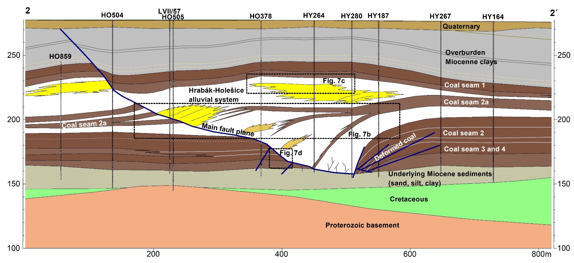
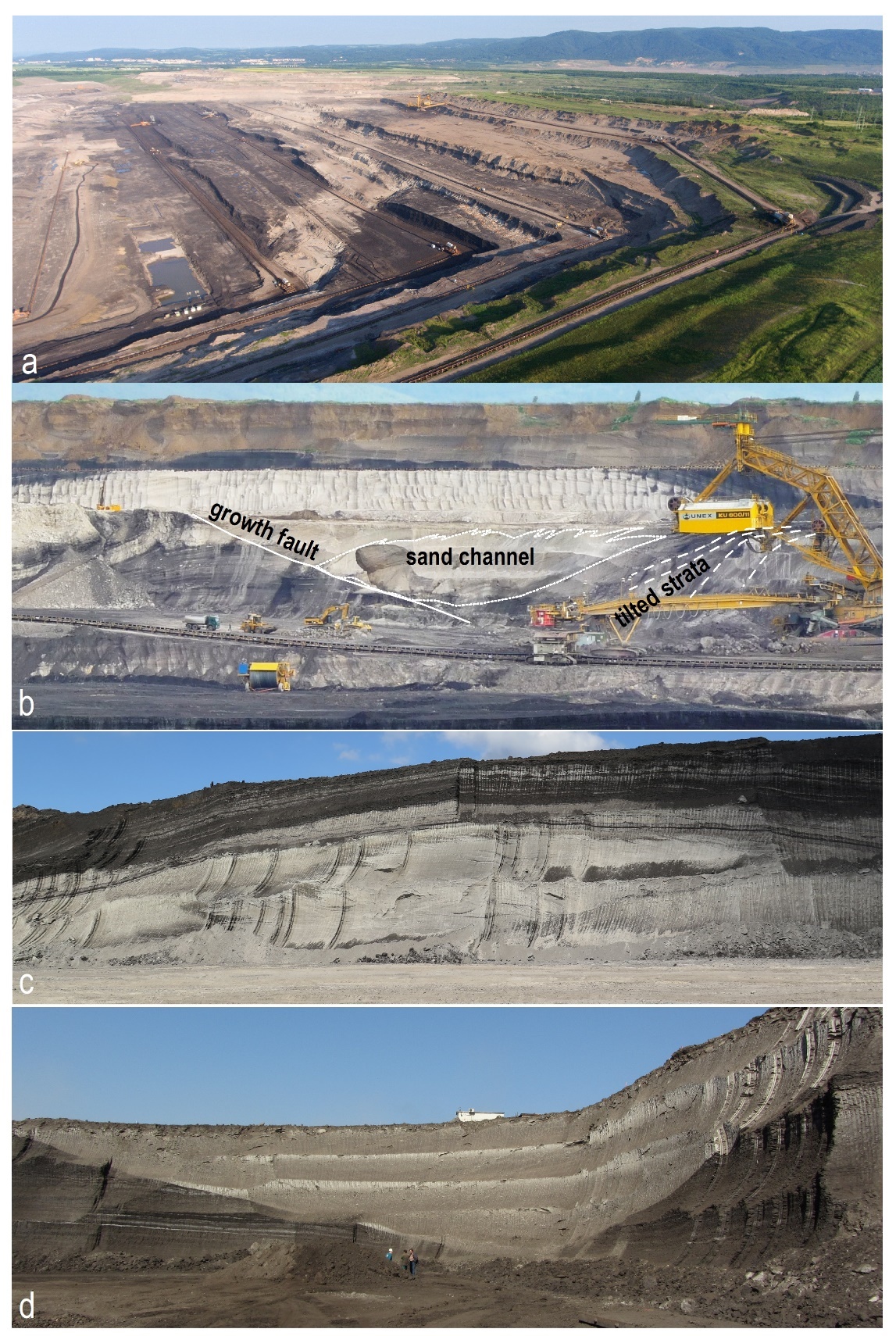
Another alluvial system, the Hrabák-Holešice system, is exposed on the opposite – eastern – side of the Žatec Delta area in the Vršany open-cast mine. This system lies in the upper part of the Main Coal Seam and its eastern edge coincides with the eastern edge of the Žatec Delta area. It can be described as an elongated clastic (clay, silt, sand) body about 10 km long and 3 km wide, with an overall thickness of 60–90 m (Fig. 5). The Hrabák-Holešice alluvial system was covered by Rajchl and Uličný (2005) who described in detail the main sedimentary facies and architectures, the sedimentary style of the system and especially the role of the underlying compaction of peat in the progradation of the alluvial system to the swampy area. However, the authors were not able to observe the easternmost part of this sedimentary unit known by prominent deformations of the coal seam and alluvial sediments (Figs. 6 and 7). It was revealed only by borehole data as an elongated band with missing coal called “vymýtina” or “syngenetical pothole” (Hurník, 1999; Štrbáň & Topinka, 1998). From the year 2014 on, the structure was exposed by mining in the Vršany Mine, providing a perfect condition for geological documentation.
_and_coal_underlying_the_hrabk-holeice.jpeg)

The easternmost part of the Hrabák-Holešice alluvial system represents the oldest stage of expansion of the fluvial system of the Central River to the peat swamp – “clastic package 1” described by Rajchl and Uličný (2005). All younger (2–5) clastic packages described by these authors were deposited on the overbank fines of this first stage. This first stage created a southeast–northwest-orientated belt of complex sand/silt/clay sediments with a total thickness of up to 90 m while the thicknesses of the other, younger stages usually do not exceed 60 m. Strata (silt, clay) within this structure are strongly inclined (up to 35°) in the lower part while the stratification in the upper part is generally horizontal. This clastic package is bordered by a fault plane (probably a growth fault) on the western side of the structure (Fig. 7d). This system of faults is almost parallel to the axis of the structure and dips beneath the structure (to the northeast). According to borehole data, the fault does not continue deeper to the underlying sediments beneath the Main Coal. This main fault is accompanied by many minor faults, often with opposite orientation. Architectural analysis is challenging because there are many irregular bodies of channel fill (sand, silt) and lacustrine sediments (stratified clays) alternating with overbank fines (massive silty clay) and dark brown to black coaly clays. Only the strata of coaly clays can be used for the discrimination of many sedimentary substages because this type of sediments can be well correlated. Owing to the presence of dark-coloured coaly clays, at least four developmental substages were identified in this easternmost clastic package. The structure is accompanied by a missing or reduced coal seam within the belt more than 3 km long and 100–300 m wide (Fig. 5). On the other hand, the eastern edge of the structure is typical by elevated thicknesses of underlying coal, reaching a maximum of 40 m. Ordinary thicknesses of coal deposited beneath the Hrabák-Holešice alluvial system are 25–30 m in the Vršany Mine area (Tab. 1). Younger stages of the Hrabák-Holešice alluvial system described by Rajchl and Uličný (2005) are not associated with any major deformation of the coal seam resulting in its absence.


Common and contrasting features of the described alluvial sedimentary systems
General features of the described alluvial sedimentary systems are summarized in Tab. 1.
It has to be mentioned that all sediments of the described alluvial systems sharply overlie older coal beds in vertical direction. This corresponds with the known avulsions of the river within the large Most Basin peat swamp area (Rajchl & Uličný, 2005). With the exception of the oldest described alluvial system on the bottom of the seam, all alluvial systems were characterized as for their deformations. Listric faults were developed at the boundary between the channel sediments and the finer overbank deposits or the coal seam. These faults are usually systematically developed on one side of the channel belt. Close to the fault, diverging stratification (mostly of silts) and a variable inclination of strata in the lower part of the channel were observed. The strike of the fault plane was always parallel to the axis of the alluvial system and the listric forms were terminated at the base of the coal seam by passing to horizontal dips. The described features of the faults are considered to be typical for growth faults (Bruce, 1973; Crans et al., 1980; Mach, 2002; Morley & Guerin, 1996). At the lower end of these growth faults, the seam is often removed down the fault dip. In some cases, the coal seam is absent in this area and can be thickened farther away from this area (Fig. 5).
Discussion
Peat thickness and overburden as controls on compaction
The study of alluvial systems of the Most Basin in an environment with underlying peat shows the direct influence of synsedimentary compaction on the development of these systems. Principal factors influencing the development of the alluvial systems appear to be the thickness of the uncompacted peat, its composition (proportion of clastics/ash) and the character of the alluvial systems (their duration, prevailing type of clastics). Of course, it has to be noted that the term “uncompacted” peat is not fully correct. The term “partly compacted” peat is a more appropriate one. The process of peat compaction in a peat swamp environment can be well described by soil mechanics formula of segment with height compaction s = h·C-1·2.3 log (σ1/ σ2), where h is the height of the segment, C is the height compaction coefficient of the material, σ1 is the starting vertical load and σ2 is the total vertical load after loading the next segment. Coefficient C used for peat is in the range of 3–7 (30–120 for clay and 150–250 for sand): more compactable materials show lower C values (Myslivec et al., 1970). Using this formula, the process of accumulation of peat and, in the second step, of clastic sediments was modelled by Mach (2002).
This modelling of gradual accumulation of peat (programmed in Turbo Pacsal with results visualised by Microsoft Excel) showed that relatively fresh peat from the upper 10cm layer is relatively rapidly compacted by subsequent layers, but after continued loading the speed of the compaction process rapidly decreases. This is explained by the fact that new loads are very low due to very low weight of the peat under the water level and the logarithmic character of the controlling formula (Fig. 8). Very similar results were presented from the Holocene Mississippi delta area (Keogh et al., 2021) where organic-rich sediments from different depths were assessed. The authors found that compaction of peat proceeds at relatively high rates in surface layers 1–3 m thick. An increasing depth of peat of up to 14 m yielded a compaction of max. 50 %. The curve of compaction potential was very similar to the curve of compaction modelling presented by Mach (2002). It is obvious that the first portion of clastic material brought by the river after its avulsion to the area of our interest created the most rapid compaction of near-surface layers of peat by the sediment load. But we can imagine that the first portion of sediment within the newly formed floodplain of the river is composed by clays or silts transported in suspended load. These layers were covering wide belts and exhausted the above mentioned compaction potential of the uppermost peat layers with no dramatic compactional effects and deformations. This is the reason why the relatively low thicknesses observed by authors (less than 5 m of peat – less than 1 m of coal today) beneath partly compacted peat with high ash content represent unimportant factor for the described alluvial system. The decreasing degree of compactibility at the depth of peat burial in the Holocene coastal plain environment in the Netherlands was also described by Koster et al. (2018; 2016), who also noticed another factor reducing compaction, namely the ash content in the peat and even vegetation type.
_and_its_alteration_by_a_later_s.jpeg)
Compaction beneath the sediments of the alluvial systems in the Most Basin – from compaction to growth faulting
Conditions with a low compaction potential arose during the development of the anastomosing alluvial system at the Libouš Mine. There is no evidence of local changes in sedimentation due to peat compaction. The system behaves as if there was no underlying peat (Fig. 9a). In the case of a higher thickness of underlying peat (more than 10 m), faster subsidence begins to occur at the site of the fastest contribution of clastic material (river channel). This subsidence creates additional accommodation space until the compaction of the underlying peat is exhausted. Differential compaction of peat at a short distance range (beneath sandy channel vs. fine overbank deposits) can lead to the build-up of shear stress and formation of listric plastic zones at the point of bending of the peat layers, usually below the edge of channel deposits, similarly like it was described in the case of deformed lacustrine deltaic sediments (Mach, 2002). As a result of further loading of the underlying peat by new portions of clastic material, this zone may turn into the formation of growth faults (Fig. 9b).

Growth faults are of listric shapes and gradually come to an end at the base of the peat layer. A movement down the fault during the sedimentation is documented by the increasing sediment thickness close to the fault and tilting of the originally horizontal strata. Gradual upward coarsening of the clastics is also observed. The Libouš alluvial system in the lower part of the Main Coal Seam is often accompanied by minor growth faults on the edge of the river channel. Synsedimentary compaction of underlying peat 30–50 m thick (5–10 m of coal today) and the movement along the growth faults provided a space of about 25 m for the alluvial sediments. Higher thicknesses of underlying peat in the Droužkovice and Hrabák-Holešice alluvial systems and the higher load contrast made by sand-dominated channel-fill accumulations compared to silts and clays of the overbank deposits led to an even more significant displacement at the growth fault thereby creating additional space for clastic sedimentation (Fig. 9c). Moreover, intensive deformation of peat due to the movement along the growth fault occurred, resulting in the formation of areas with missing coal beneath the original river channel. Here, missing coal was replaced by younger alluvial clastic sediments due to the large movement along the growth fault. The original coal beds were probably pushed away and laterally compressed in the case of the Hrabák-Holešice system. This is evidenced by the elevated thicknesses of the coal seam on the eastern side of the alluvial system. No evidence of synsedimentary erosion of the deformed coal seam was found.
In the Hrabák-Holešice system, horizontal compaction is documented by the uninterrupted course of strata, which are significantly bent into a slight anticline at the place of elevated thicknesses of the coal seam (east of the structure). Smaller thrust surfaces were observed only in the lower part of the emplaced coal seam. Thicknesses of the underlying partly compacted peat were ca. 100–150 m (25–35 m of coal today) in the Droužkovice and Holešice-Hrabák systems with average ash contents of 30–40 %. Lower thicknesses of the Droužkovice alluvial system sediments in its SW part are caused by partial exhaustion of the compaction potential by the older Libouš alluvial system, especially by its floodplain deposits. The same was documented in the Holešice-Hrabák alluvial system. Major synsedimentary deformation (growth faulting) occurred only during the first stage of progradation of the river to the Vršany area peat swamp. Later, younger sediments were deposited on floodplain sediments of the first river stage west of the Vršany “pothole”. These floodplain sediments partly exhausted the compaction potential, and younger sediments were deposited also in considerable thicknesses but no obvious deformation or growth fault formation. Only intensive aggradation of the channel fill was reported from this area by Rajchl and Uličný (2005). Noteworthy is the gradual predominance of sand over silt component in the fill of the river channel in the younger part of the Hrabák-Holešice system. The lower part of the system, where a significant subsidence took place due to compaction, is dominated by horizontally stratified silt, while sand lenses are rather rare at the closest to the growth fault. Younger stages, during which the movement along the growth fault was almost exhausted, are dominated by sand with a typical trough cross bedding in the fill of the channels (Fig. 7c). This way, the character of the deposited sediments in the river channel was clearly affected by the subsidence rate.
A much higher thickness (up to 200 m) of peat with low ash content created conditions for the emergence of a deltaic environment in the Bílina area. Here, unlike in the described areas, compaction by sediments of the initial floodplain led to the formation of a lake into which the delta fans prograded. Here, river mouthbars were also accompanied by strong synsedimentary deformations (Mach, 2002). The maximum thicknesses of the Bílina Delta complex deposited due to the compaction of the peat layer are 120–150 m depending on the underlying peat thickness. Floodplains of the described alluvial systems of the Žatec Delta did not cause such significant compaction as in the Bílina Delta due to the lower thickness of the peat layer, higher contents of clay/ash formed by abundant clay partings within the coal seam and higher proportions of clay within the coal beds (lower compaction potential).
Parameters controlling the capacity of peat compaction
The above data on the thickness of coal and clastic sediments can be displayed using a diagram (Fig. 10) of the relation between the maximum local thickness of newly deposited clastic fluvial strata and a newly designed artificial parameter called “apparent available compaction capacity” (AACC) by the present authors. Apparent available compaction capacity of the underlying coal seam is defined as the ratio between the undeformed thickness of the underlying coal seam and the average ash content in this seam. Thickness of the coal seam clearly shows a positive correlation with the total possible accommodation space, which can be created by compaction under the load of the alluvial sediments in the overburden. On the other hand, the possible compaction ratio decreases with the increasing ash content in the coal seam showing the quality of coal. This finding is in accord with the results of Keogh et al. (2021) who also found that sediment compaction is effectively controlled by organic content as well as overburden thickness and density (which together determine effective stress). Also, Stouthamer and Van Asselen (2015) during their estimation of surface subsidence due to sediment loading of Holocene peat layers in the Rhine Delta concluded that in compacted peat layers, high-organic peat generally compacts to a higher degree than low-organic peat. A reduction of compactibility of peat by high amounts of ash was also described by Koster et al. (2018) from Holocene peat in the Netherlands coastal plain. A very similar diagram was also presented by Tornqvist et al. (2008) monitoring the predominantly linear relationship between overburden thicknesses and compaction rates.
_.jpeg)
The AACC parameter was calculated for several borehole sections of the studied alluvial sedimentary systems and included in the table (Supplementary material II). The diagram constructed on the basis of this table shows a clear linear correlation between the AACC and the maximum thickness of the alluvial system deposits in the compacted overburden of peat layer/coal bed. An added point illustrating the maximum formed accommodation space in the Bílina Delta conditions shows that the linear relation between the discussed parameters can be used for the prediction of possible addition of accommodation space for sediments due to a coal seam/peat layer of known parameters.
Summary
-
Synsedimentary compaction of a thin layer (a few metres) of peat does not play a fundamental role in the development of the alluvial system. Peat thicknesses of a few tens of metres cause uneven compaction leading to the formation of small deformations of the underlying peat layer and sediments locally resulting in the formation of smaller growth faults. Underlying peat thicknesses of over 100 m usually result not only in the accumulation of considerable thicknesses of clastic sediments due to compaction but often lead – especially in areas of load contrast due to channel fill sand accumulation – to major deformations of the peat layer/coal bed and alluvial sediments along growth faults.
-
A significant displacement of a peat layer along the growth fault can also lead to lateral compaction of peat in the subsided block, as was documented in the Vršany Mine.
-
The maximum thickness of the alluvial sediments loading the peat layer has a linear relation to the maximum instantaneous available compaction capacity of underlying peat.
-
The described cases of synsedimentary compaction with peat deformation beneath alluvial systems sediments lack a modern equivalent because the maximum thicknesses of modern peat deposits usually do not exceed 5–10 m.
Acknowledgments
The authors wish to thank Petr Šulcek, Ingrid Bejšovcová and Radomil Filipík of the Sev.en Inntech a.s. company (Vršanská uhelná a.s.) for their permission to visit the Vršany quarry and for providing geological data, photos and maps. Severočeské doly a.s. is thanked for providing data and financial support. Michal Rajchl and David Uličný helped with sedimentological discussions and Pavel Coufal provided a few photos. Authors are grateful also to Jiří Adamovič for his language proofediting. The level of the paper was raised by the comments of reviewers and journal editors, many thanks to them.