INTRODUCTION
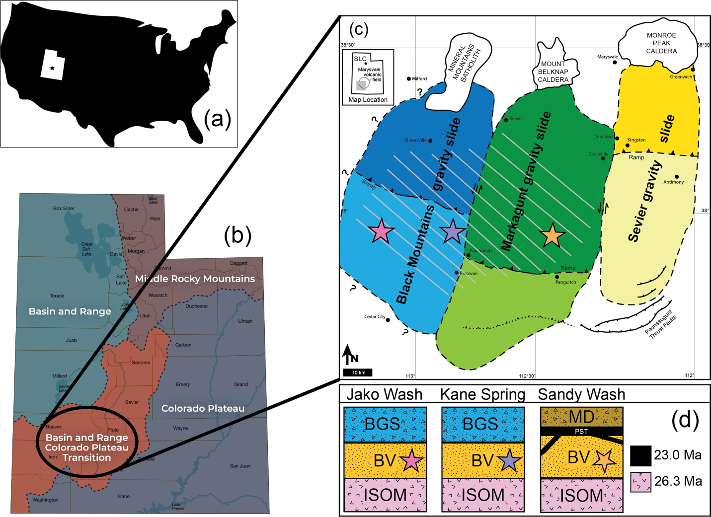
Situated in the High Plateaus physiographic province of southwestern Utah, the late Oligocene-to-Miocene Marysvale volcanic field (Figure 1) offers important information on the large-scale instability of volcanic fields. During the growth of the volcanic field, the southern part of the field experienced three sequential mega-scale collapse events (Figure 1), collectively known as the Marysvale gravity slide complex, underlying an area >8,000 km2 (MGSC; Biek et al., 2022). From east to west, the MGSC is composed of the 25.3 Ma Sevier (Rivera et al., 2025), 23.0 Ma Markagunt (Holliday et al., 2022), and ~21 Ma Black Mountains gravity slides (Stevens et al., 2023). Each gravity slide was differentiated by geological mapping, and radioisotopic dating of deformed and undeformed volcanic rocks provided a numerical age for each gravitational collapse (Biek et al., 2015, 2019, 2022; Braunagel et al., 2023, 2025; Hacker et al., 2014, 2017; Holliday et al., 2022; Mayback et al., 2022; Zamanialavijeh et al., 2021).
_the_united_states_wi.png)
The Marysvale volcanic field is the largest volcanic field in Utah, with a diameter of ~100 km. It is made up of calc-alkaline (mostly andesitic to dacitic) and bimodal (basalt and rhyolite) volcanic rocks and their intrusive equivalents, all complexly interbedded as thick (50-200 m) successions of lava flows, tuffs, and volcaniclastic strata (Cunningham et al., 1983, 1998, 2007; Cunningham & Steven, 1979; Rowley et al., 1994, 2005, 2020; Sable & Maldonado, 1997; Steven et al., 1979). During a relative lull in volcanic activity in the late Oligocene to early Miocene (ca. 27-24 Ma), a >300 m thick vitric volcanic arenite, known as the Bear Valley Fm., accumulated over an area of >2,500 km2 in a low-topography structural basin (Anderson, 1971). The Bear Valley Fm. is present on the Markagunt Plateau and extends westward into the Red Hills and Black Mountains but is not found on the Sevier Plateau to the east (Figure 1). The arenite thins to the west and the proportion of volcanic glass shards decreases, suggesting that more tuff-producing eruptions were present in the east during sand deposition.
Here we test if the sedimentary record preserved in the Bear Valley Fm. can tell us more about the buildup of a volcanic field and its change in source provenance prior to the collapse and deposition of the Markagunt gravity slide. We posit that the Bear Valley Fm. records the spatial and temporal evolution of the landforms built by igneous activity. This study presents new detrital zircon U/Pb dates for the Bear Valley Fm. to refine the sedimentary provenance of the Bear Valley Fm., and provide insights into the sedimentary and tectonic conditions in the Marysvale volcanic field between the emplacement of the Sevier and Markagunt gravity slides. These data are significant because they offer constraints on sediment transport pathways, source terrane contributions, and depositional environments within the Marysvale volcanic field. By improving the temporal and stratigraphic framework of sedimentation between the emplacement of the Sevier and Markagunt gravity slides, this study advances our understanding of the regional tectonic evolution, paleogeographic reconstructions, and magmatic processes that shaped this complex volcanic and sedimentary system. The conceptual model presented here proposes the emergence of small-volume local eruptions accompanied by an acceleration in uplift within the <500 kyr immediately preceding the collapse of the MGS, followed by a subtle westward shift in volcanic activity during this period.
BACKGROUND
During geologic mapping in the southern Marysvale volcanic field, Anderson (1971) defined and described two informal members of the Bear Valley Fm. at a type section (37.9679 N, -112.4642 E) he proposed in the northern Markagunt Plateau. Both members are characterized by large scale (2 m), high-angle eolian cross-beds that accumulated under arid conditions. At the type section, the upper member is >100 m thick with a high (20-30%) percentage of subangular to angular glass shards and quartz, interpreted as derived from local, contemporaneous volcanic eruptions (Anderson, 1971). To the west and south of the type section, the upper portion of the Bear Valley Fm. contains lava flows, volcanic mudflow breccias, and ash-flow tuffs, including one tuff with an age of 23.9 ± 0.8[1] Ma and another 45 m thick tuff with an age of 24.0 ± 0.6 Ma (Anderson citing preliminary data from R.J. Felck, oral commun.). Fleck et al. (1975) reported K-Ar ages from the upper member of 24.6 ± 0.8 Ma and 24.5 ± 1.0 Ma (corrected according to Dalrymple, 1979). Zircon from a tuff in the upper member yielded an age of 24.59 ± 1.92 Ma (Biek et al., 2015). The lower member lacks glass shards but includes abundant reworked volcanic material that is not present in the upper member (Anderson, 1971). These volcanics have been interpreted as sourced from the west through episodic reworking of older volcanic units, such as the underlying Isom or Wah Wah Springs formations, a hypothesis supported by paleocurrent data (Anderson, 1971). Anderson (1971) concluded that the stratigraphic transition reflects a shift in sediment source areas from the west to the north, with increasing sediment contributions from three volcanic centers now located on the Markagunt Plateau. This change in source area likely resulted from the progressive buildup of a volcanic edifice, which ultimately collapsed, leading to the emplacement of the Markagunt gravity slide at 23 Ma (Biek et al., 2014, 2015, 2019; Hacker et al., 2014, 2017; Holliday et al., 2022; Mayback et al., 2022).
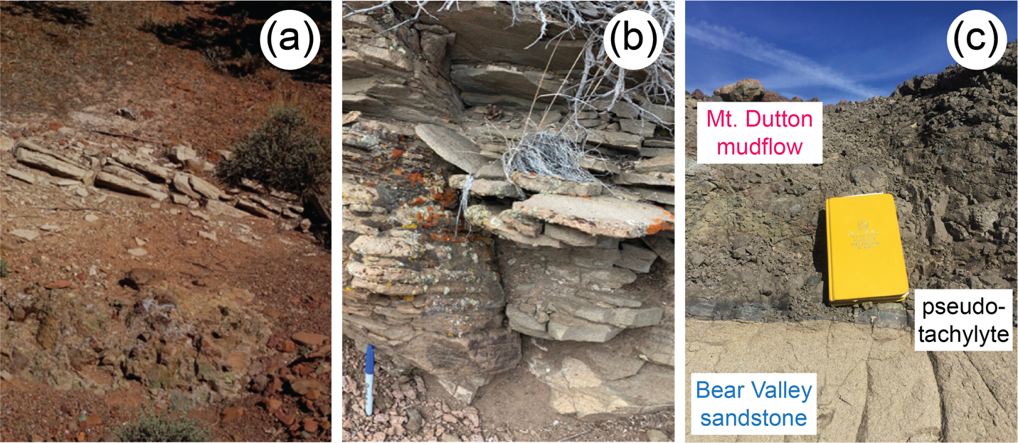
The Bear Valley Fm. is overlain by the Mount Dutton Fm. composed of volcanic mudflow breccias, local ash-flow tuffs, and lava flows. At the Sandy Wash locality, the Bear Valley Fm. is located on the allochthonous block of the Markagunt gravity slide. During slide movement, pseudotachylyte (PST) was generated at the contact of the Bear Valley Fm. and the overlying volcanic mudflow breccias (Hacker et al., 2014; Biek et al., 2013). 40Ar/39Ar dates for the PST and volcanic tuffs bracketing the gravity slide deposits yield an age of 23.05 +0.22/-0.20 Ma for the gravity slide (Holliday et al., 2022). Because PST intrudes the Bear Valley Fm., the gravity slide age provides an upper limit on the timing of Bear Valley deposition. The Bear Valley Fm. overlies an ash-flow tuff of the 26-27 Ma Isom Formation (Rowley et al., 1994). The source of the Isom ash-flow tuff is unknown but likely derived from eruptions of the large (60 by 100 km) 29-36 Ma Indian Peak caldera complex that spans the Utah-Nevada border and located ~40 km southwest of the Marysvale volcanic field (Best et al., 2013; Rowley et al., 1979). Given the existing geochronology at the time, Anderson (1971) constrained the age of the Bear Valley Fm. as younger than the ~27 Ma Isom Fm. which it overlies, and older than ~24 Ma, the age of ash-flow tuffs in its upper part. Based on new 40Ar/39Ar geochronology, Holliday et al. (2022) asserted that the deposition of Bear Valley strata, the emplacement of the Markagunt gravity slide, and the eruption of the overlying Haycock Mountain Tuff occurred within an ~500 kyr interval.
The Bear Valley Fm. is thickest (300 m) at its easternmost extent and thins towards the west. The thinning is accompanied by a decrease in the abundance of glass shards, with the westernmost Bear Valley outcrops completely devoid of glass shards. Eolian deposition occurred in a low-topography structural basin. The eastern boundary is a presumed volcanic topographic high near both the western edge of the 25 Ma Sevier gravity slide and the post-20 Ma basin-range Sevier fault zone that uplifted the Sevier Plateau to its present height (Anderson, 1971; Rivera et al., 2025). The northern extent of the Bear Valley Fm. is bound by a >300 m fault scarp generated from the 26 Ma Spry intrusion (Anderson et al., 1990; Rowley et al., 1994). The western and southern extents are poorly defined as the Bear Valley Fm. simply thins out. Overall, the sandstone thickens uniformly towards the north and east, with no evidence of sharp differences in thickness along an east-west profile.
Marysvale volcanic rocks are temporally related to correlative strata in the White River Group of the central Rocky Mountains and western Great Plains. Malone et al. (2022) and Moll et al. (2024), in their studies of White River Group strata in Wyoming and at Slim Buttes in South Dakota, interpret that during the late Oligocene, large volumes of material were transported by fluvial and eolian processes > 1000 km northeast from source areas in the Marysvale volcanic field.
_poorly_exposed_bear_valley_fm._at_jako_wash._(b)_thin_.png)
METHODS
Three localities at approximately the same latitude across a 50-km transect were selected to obtain representative samples across the thinning wedge of Bear Valley Fm. sandstone (Figures 1 and 2; Table S1). This present-day spatial distribution of the sampling localities has been disrupted by both the emplacement of the gravity slides and subsequent basin-range style extension, making it difficult to precisely reconstruct their relative positions at the time of deposition. Sampling was restricted to the uppermost part of the upper member, correlative to unit E of Anderson (1971). Approximately 5 kg of material was collected from each site, crushed, and processed for zircons using standard density and magnetic separation techniques. The easternmost sample at Sandy Wash was collected from massive cross bedded sandstone ~50 m above the base of the Markagunt gravity slide and thus belongs to the allochthonous block of the gravity slide. The sample from Kane Spring was also collected from a massive cross-bedded sandstone, ~50 m below the base of the Black Mountains gravity slide and is thus within the autochthonous block of the gravity slide. Jako Wash is the westernmost location. Here, the sample was collected from a ~10 m interval of sandstone immediately underlying the Black Mountains gravity slide and is thus autochthonous. We also sampled the Isom ash-flow tuff which underlies the Bear Valley Fm. at all locations (Figure 1), providing a maximum age for Bear Valley deposition. Zircon U/Pb geochronology was conducted at the Arizona LaserChron Center via a ThermoScientific Element2 ICPMS coupled to a 193 nm Teledyne ArF laser. Details of analytical protocols and data filtering methods are provided in the supplemental files. Maximum depositional ages were calculated as maximum likelihood ages (MLA) in IsoplotR using the algorithms of Galbraith and Laslett (1993) and Vermeesch (2021). Ages and uncertainties are reported at 2σ in the format of x ± y | z, where x is the maximum likelihood age, y is the analytical uncertainty, and z includes systematic errors propagated in quadrature.
RESULTS
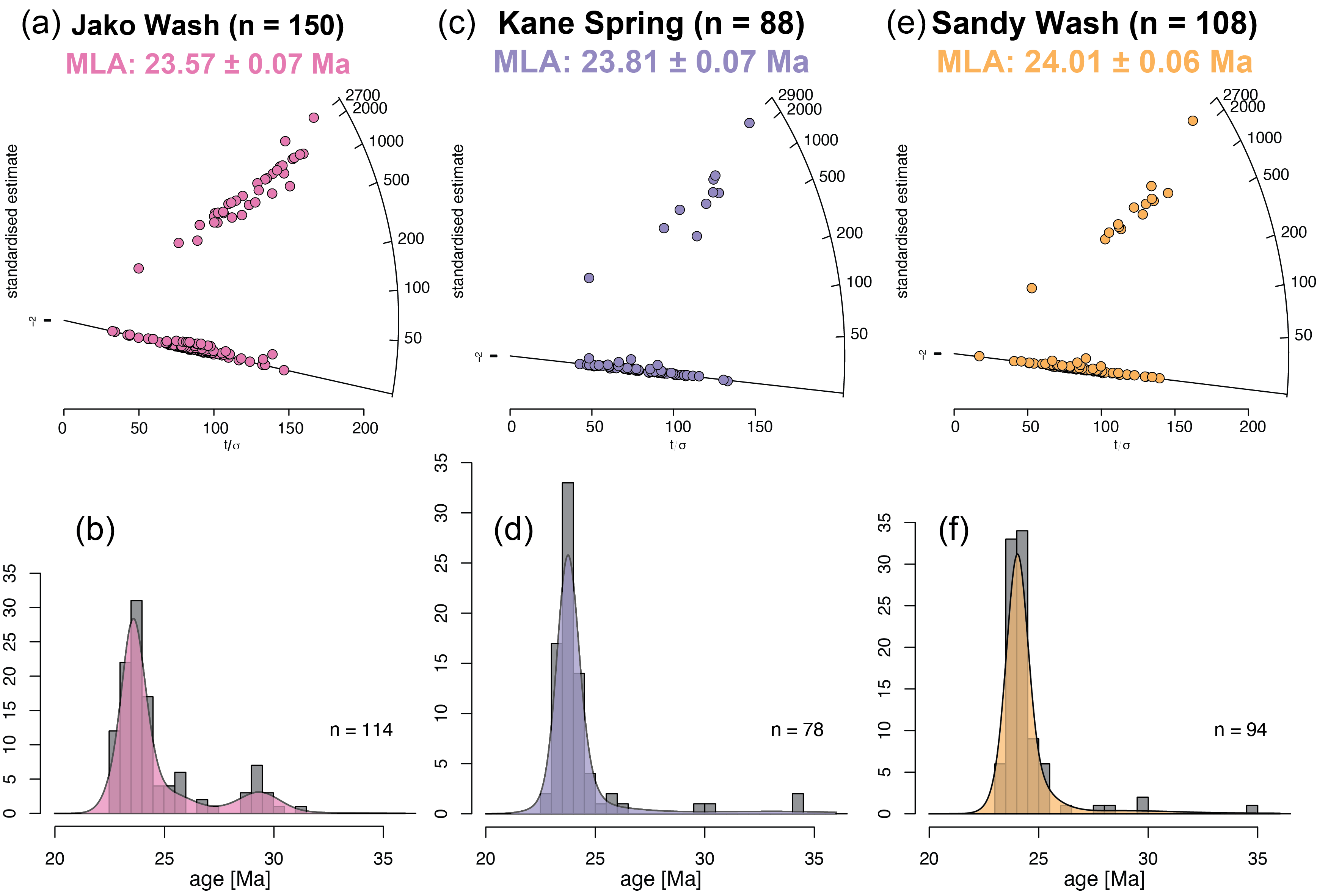
Age distributions of Cenozoic grains are presented as radial diagrams and kernel density estimates generated using IsoplotR (Vermeesch, 2018; Figure 3). Cenozoic zircon dates for the three sample sites range from ~22.5 Ma to ~35 Ma (supplemental files). At Jako Wash, the detrital zircon U/Pb dates (n = 114) range from 22.55 ± 1.03 Ma to 31.28 ± 0.45 Ma, with a MLA of 23.57 ± 0.07 | 0.60 Ma1 (Figures 3a and 3b). At Kane Spring, the detrital zircon U/Pb dates (n = 78) range from 22.61 ± 0.74 Ma to 34.32 ± 0.93 Ma, and yield a MLA of 23.81 ± 0.07 | 0.60 Ma (Figures 3c and 3d). Detrital zircon U/Pb dates (n = 94) from Sandy Wash ranged from 23.18 ± 0.46 Ma to 34.82 ± 0.78 Ma (Figures 3e and 3f). A MLA for Sandy Wash zircon is 24.01± 0.06 | 0.60 Ma (Figure 3e). Twenty-one zircon U/Pb dates for the Isom ash-flow tuff range from 26.09 ± 0.79 Ma to 34.97 ± 1.09 Ma, with the youngest four grains yielding a weighted mean age of 26.33 ± 0.10 Ma (supplementary materials). All samples contained Proterozoic and Archean zircon with modes at 1,100 Ma and 1,700 Ma (supplementary materials).
_and_kernel_density_estimates_(b__d__f)_of_detrital_zircon_u_pb_age_.png)
DISCUSSION
Depositional Timing, Tectonic Implications, and Sediment Provenance of the Upper Bear Valley Formation
Based on detrital zircon maximum depositional ages, the upper member of the Bear Valley Fm. sandstone was deposited from ~24.0 ± 0.6 to 23.6 ± 0.6 Ma, suggesting deposition within a short interval immediately preceding the emplacement of the MGS at 23.05 +0.22/−0.20 Ma (Holliday et al., 2022). The abundance of primary angular volcanic glass (20-30%) within the upper member of the Bear Valley sandstone (Anderson, 1971) implies that sediment was sourced from an array of local vents. The decrease in glass abundance to the west is due to the increased distance between the vents and the depositional basin at Jako Wash.
The MLAs for the Sandy Wash and Kane Spring localities (23.8-24.0 Ma) suggests sediment sourcing was predominantly influenced by newly emergent, proximal source areas within the northern Marysvale volcanic field. The paucity of pre-Oligocene zircons in these age spectra suggests that older Marysvale sources were either buried or located farther downslope, supporting the interpretation of a newly emergent, high elevation sediment source situated to the north, i.e. the volcanic center that collapsed to generate the MGS.
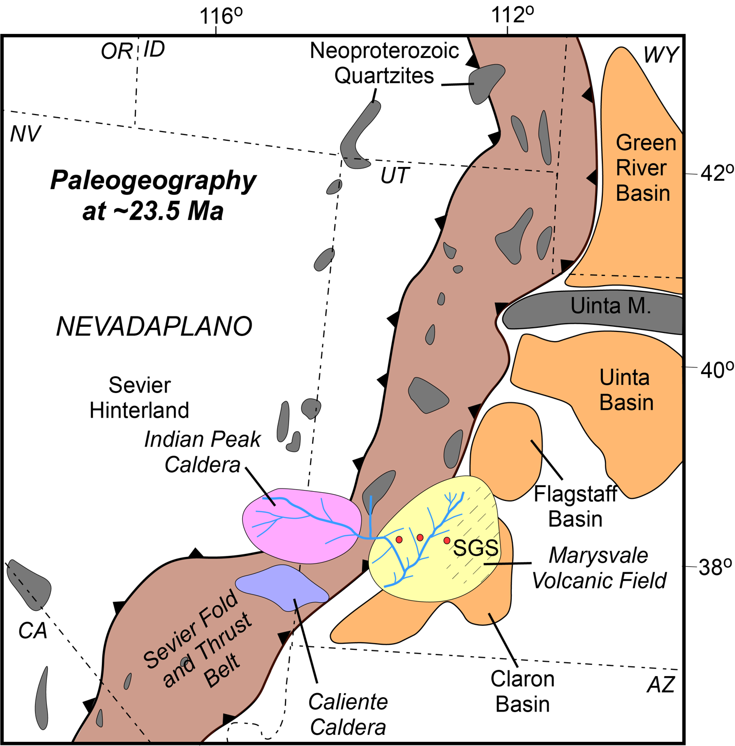
The 23.6 Ma MLA for the Jako Wash sample also reflects the emergence of a new volcanic sediment source to the north. However, a mode at 29.4 Ma indicates an additional sediment contribution from older sources. Older zircon grains are interpreted to have been derived from regional ash-flow tuffs, such as the Wah Wah Springs, Isom, and Leach Canyon formations, that were initially deposited in a series of paleovalleys that radiated eastward from the Indian Peak/Caliente caldera complex to the west that was active from 36 to 29 Ma (Best et al., 2013). The sediment source at Jako Wash gradually shifted southward over time as the Marysvale volcanic field developed (Biek et al., 2015; Figure 4). By the time the Bear Valley Fm. was deposited, the Marysvale highlands had emerged as a primary zircon-rich sediment source, significantly influencing the detrital zircon age spectra. The presence of Proterozoic zircons within the detrital zircon age distribution suggests a contribution from recycled Neoproterozoic-Paleozoic strata in the Sevier foreland fold and thrust belt or hinterland (Cull, 2025; Malone et al., 2022) particularly in the vicinity of the Indian Peak caldera complex, which further supports the interpretation of more distal sediment sourcing for the uppermost Bear Valley Fm.

Implications for the Catastrophic Collapse and Emplacement of the MGS
Our findings indicate that the thick accumulation of the sediment comprising the upper Bear Valley Fm. occurred over a 600 kyr period during the million years preceding the collapse and emplacement of the MGS. This interpretation aligns with a period of volcanic quiescence in the northern Marysvale volcanic field following the eruption of the 25.19 Ma Antimony Tuff Member of the Mount Dutton Fm. (Rivera et al., 2025). The lack of extensive contemporaneous volcanic deposits, few intercalated tuffs, no interbedded lahars, and the high abundance of glass shards (Anderson, 1971) implies that sediment contribution to the Bear Valley Fm. originated from erosion of newly emergent, zircon-rich, small volume, local eruptions in the northern Marysvale volcanic field. We propose that these eruptions were accompanied by rapid uplift and thermal doming of the volcanic field. The accelerated surface uplift and resultant sediment influx may have contributed to increasing gravitational instability within the region, ultimately culminating in the catastrophic collapse and emplacement of the MGS at 23 Ma. This interpretation supports a model in which sedimentation, uplift, and gravitational failure were closely linked processes in the late-stage evolution of the Marysvale volcanic field.
Relation to Correlative Strata in the Rocky Mountains and Great Plains
The Oligocene-Miocene White River Group and overlying Arikaree Group represent the predominant stratigraphic units of Bear Valley age occurring throughout the Rocky Mountains and western Great Plains. Recent provenance studies of these rocks by Malone et al. (2022) and Moll et al. (2024) have identified a high concentration of 30-20 Ma zircons within White River strata, particularly in exposures atop the Laramide Bighorn Mountains of north-central Wyoming and Slim Buttes of northwestern South Dakota. Both studies attribute these zircon ages to sediment sources in the Marysvale volcanic province or large caldera complexes such as the Indian Peak and Caliente calderas in the Great Basin. The dominance of zircons derived from these volcanic centers presents two possible mechanisms of sediment transport. One scenario involves a northeastward-flowing fluvial system that transported volcanic detritus from Utah and Nevada to South Dakota and Wyoming. Alternatively, long-distance eolian processes may have carried ash and fine-grained sediment over 1,000 km to the northeast. The latter hypothesis is favored given the proposed eolian origin of the Bear Valley Fm., which is correlative to the Brule Formation of the White River group. The widespread distribution of volcanic zircons across the Great Plains supports the role of atmospheric transport in dispersing fine volcanic material over extensive distances, consistent with regional paleoclimatic and sedimentary reconstructions (Malone et al., 2022; Moll et al., 2024). This is similar in scale to eolian transport of zircon determined for the Bighorn Dolomite in Wyoming (Malone et al., 2017) and for late Paleozoic strata in equatorial Pangaea (Soreghan et al., 2019).
CONCLUSION
This study refines the depositional framework of the Bear Valley Fm., elucidates sediment transport pathways, and constrains the timing of key tectonic events in the Marysvale volcanic field. The integration of detrital zircon U/Pb geochronology with existing geological constraints highlights the complex interplay between sedimentation, volcanism, and gravitational collapse. The uppermost Bear Valley Fm. provides critical evidence for the rapid construction of a volcanic edifice that contributed to the gravitational instability leading to the collapse and emplacement of the MGS at ~23 Ma. The detrital zircon U/Pb age spectra indicate a dominant, young, sediment source(s) in the rapidly expanding Marysvale volcanic field, suggesting that volcanic activity and thermal doming played a crucial role in preconditioning the region for large-scale gravitational failure. This expansion ultimately led to the cessation of Bear Valley sedimentation as the collapse and emplacement of the MGS restructured the regional sedimentary and tectonic landscape.
ACKNOWLEDGEMENTS
Funding for this research was provided by the National Science Foundation EAR2113158, EAR2412838 and the Illinois State University Foundation. EAR2050246 supported the Arizona LaserChron Center operations. Samples for this work were obtained from the homelands of the Ute, Southern Paiute, and Goshute people.
Uncertainties are reported at 2σ unless otherwise indicated.