INTRODUCTION
Submarine canyons are incisional features on continental shelves and act as conduits for large volumes of sediment transferred from continents to oceans (e.g., Fildani, 2017; Shepard & Dill, 1966). The location and spacing of submarine canyons, their geometry and orientation with respect to the regional slope, and their connection to a sediment input, can be strongly affected by tectonics (e.g., Le Dantec et al., 2010; Maier et al., 2018). Shifting shorelines associated with tectonic movements can drive bedrock incision and formation of river valleys and submarine canyons, often strongly controlled by the inherited and/or developing structural grain (e.g., Buffington, 1964). Therefore, the timing of incision and filling of submarine canyons, and their relationship to structural fabric, can inform the timing and style of tectonic activity at plate margins.
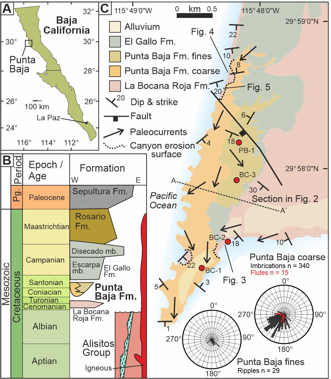
The Mesozoic stratigraphy of the Peninsular Ranges forearc basin complex of the Pacific coastal margin of northwestern Baja California and southwestern California provides a high-resolution record of a long-lived convergent plate boundary (Busby et al., 1998). The margin evolved from a highly-extensional intraoceanic arc, through a fringing arc stage, to a compressional continental arc characterized by oblique convergence (Busby et al., 1998; Engebretson et al., 1985; Glazner, 1991). From the mid-Cretaceous onwards the shift to a compressional stress regime was marked by reverse faulting and an influx of coarse sediment shed across a narrow shelf into forearc basins associated with batholith emplacement and unroofing (Busby et al., 1998; cf. Kimbrough et al., 2001). Although these forearc basins were strongly controlled by strike-slip deformation associated with compression (Busby et al., 1998), the timing of stress regimes on the Pacific margin remains poorly constrained (Busby et al., 1998; Kimbrough et al., 2001). This uncertainty hinders paleogeographic reconstructions and constraining plate motions relative to the Pacific plate. To address this we examine several unconformity bound sedimentary successions and their structural relationships, tied to new age constraints from a large-n detrital zircon dataset and micropaleontology.
STRATIGRAPHY
The Peninsular Ranges stratigraphy can be broadly divided into the ‘pre-batholithic’ and ‘post-batholithic’ rocks of the magmatic arc, which lies below but predominantly to the east of the modern coastal margin (Gastil et al., 1975). The pre-batholithic Alisitos Group (140–100 Ma; Allison, 1974; Busby, 2004) includes a wide variety of volcanic and sedimentary rocks that crop out discontinuously from the Agua Blanca Fault south of Ensenada, to the Baja California National Park of the Central Desert in the South (Busby, 2004; Fackler-Adams & Busby, 1998; Gastil et al., 1975). The Alisitos Group forms the basement to a thick succession of Upper Cretaceous sedimentary rocks forming the ‘post-batholithic’ succession.
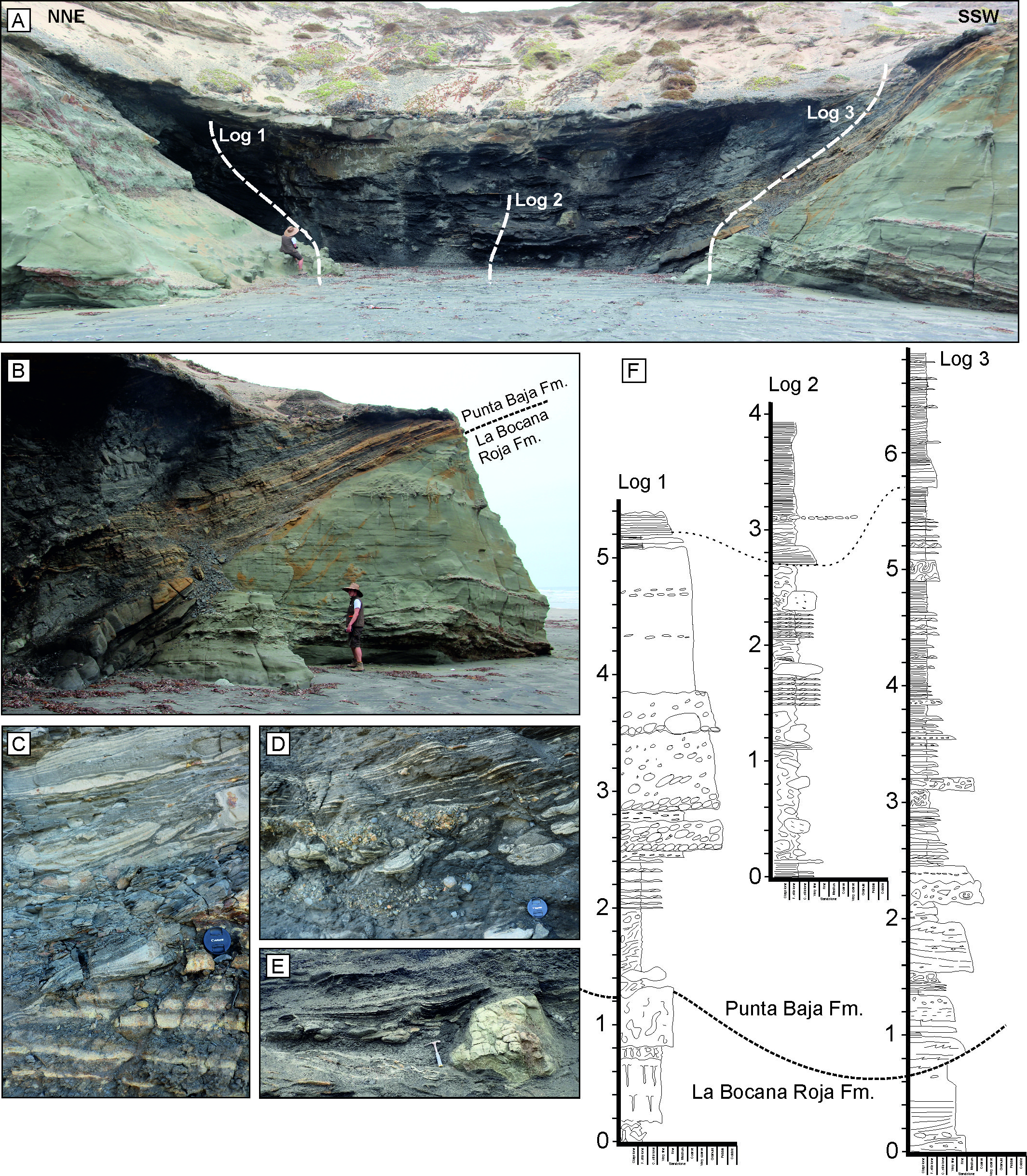
The post-batholithic succession of the study area (c. 90 Ma and younger; Gastil et al., 1975) was deposited on the eastern side of the west-facing Peninsular Ranges forearc basin complex (Bottjer & Link, 1984; Gastil et al., 1975). These rocks crop out discontinuously along the Pacific coastal margin of northern Baja California and southern California (Beal, 1948; Gastil et al., 1975). The stratigraphy comprises, from base to top: 1) a non-marine interval of fluvial channel-fills, overbank deposits and paleosols (La Bocana Roja Fm.), 2) submarine canyon-fill strata (Punta Baja Fm.), 3) shallow marine deposits transitioning to fluvial red-beds and paleosols (El Gallo Fm.), and 4) a shallow- to deep-marine succession of continental shelf to slope strata (Rosario Fm.) (Fig. 1) (Kilmer, 1963). Unconformable contacts between each of these formational units record basin-ward tilting and associated faulting and folding. Together these are overlain unconformably by a thick package of Paleogene to Neogene sedimentary and lesser volcanic rocks. Sedimentological features of the Punta Baja Fm. canyon-fill, which is the focus of this study, have been described by Boehlke and Abbot (1986) and Morris and Busby (1996).
_baja_california_peninsula__b)_stratigraphy_of_the_study_area_modified_from_busby_et_al._(.jpg)
La Bocana Roja Formation
La Bocana Roja Formation (Kilmer, 1963) is a c. 675 m thick succession of fluvial sandstones and mudstones (Schile, 1974). The basal contact with the underlying Alisitos Formation is not exposed and initially Kilmer (1963) had suggested that the Bocana Roja might be a stratigraphic equivalent of the lowermost El Gallo Formation; subsequent dating work and the results presented below suggest that the latter is significantly older. This unit forms the bedrock to the Punta Baja Formation canyon.
The Punta Baja Formation
Kilmer (1963) introduced the general stratigraphy of the Punta Baja Formation but it was Boehlke & Abbot (1986) who made the first detailed study of the Formation. The maximum exposed thickness of the Punta Baja Fm. is c. 120 m thick (Schile, 1974) and is an unconformity-bound stratigraphic interval of bathyal sedimentary rocks, interpreted to have been deposited within a submarine canyon (Boehlke & Abbott, 1986).
Within the Punta Baja Formation, Kilmer (1963) recorded the ammonite Metaplacenticeras pacificum, suggesting that a middle Campanian age (Schile, 1974), however, an Early Campanian age was determined by Boehlke & Abbott (1986) based upon the presence of calcareous nannofossils (Phanulithus ovalis, a now outdated synonym of Calculites ovalis). ‘Giant’ specimens of the bivalve Glycymerita veatchii, transported within gravity flows, are found in pebbly sandstones of the Punta Baja Formation (Squires, 2010); these are considered to range in age from the late middle Campanian to late Campanian which coincides with the lower half of the Metaplacenticeras pacificum ammonite biozone (Squires, 2010).
The El Gallo Formation
The El Gallo Formation is a ~1300 m thick succession of shallow marine and fluvial deposits (Kilmer, 1963; Renne et al., 1991; Schile, 1974). Kilmer (1963) divides the E1 Gallo Formation into three informal members: 1) the La Escarpa member, a c. 150 m thick conglomeratic unit representing alluvial fan to braided stream deposits; 2) the El Disecado member, an overlying finer-grained fluvial to tidal member (840–1150 m thick), and 3) the El Castillo member, a laterally discontinuous, poorly-sorted conglomeratic unit that is contained within the El Disecado member, but only preserved toward the east of the present study area (Schile, 1974).
DATA AND METHODOLOGY
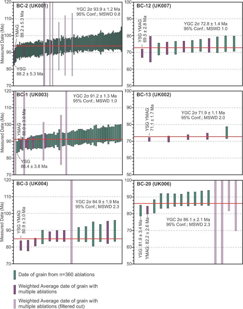
Stratigraphic, sedimentological (including paleocurrents from ripple foresets, clast imbrication and sole structures) and structural data were collected in the field, alongside samples for detrital zircon (Fig. 1, Table 1), micropaleontological, and palynological analysis. Detrital zircons were extracted from samples (N = 8) collected from the La Bocana Roja, Punta Baja, and El Gallo formations; U/Pb ratios and dates of three hundred grains from each sample were obtained using Laser Ablation – Inductively Coupled – Plasma Mass Spectrometry (LA–ICP–MS) following the methodology of Matthews and Guest (2016). Sandstone maximum depositional ages (MDAs) were calculated using the YGC 2σ methodology (Dickinson & Gehrels, 2009), as this has been demonstrated to produce accurate and precise results (Coutts et al., 2019). Where possible, the youngest detrital zircon grains were reablated to test the isotopic homogeneity of the grain(s) used in the calculation of the MDA and to reduce uncertainty (Spencer et al., 2016).
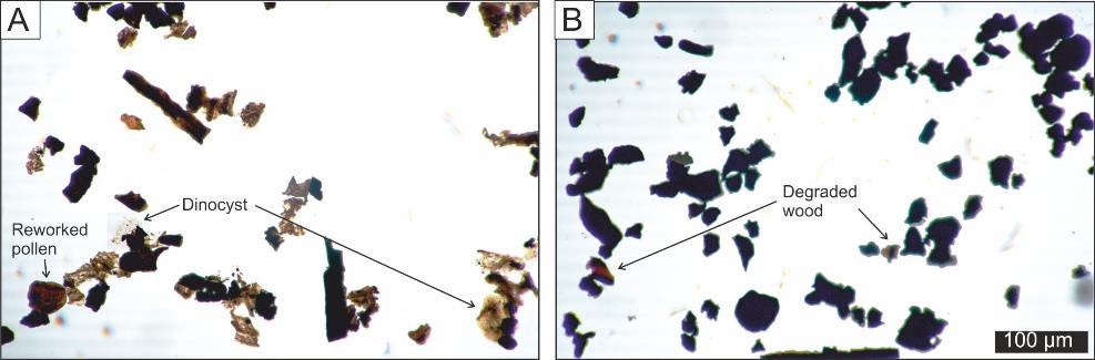
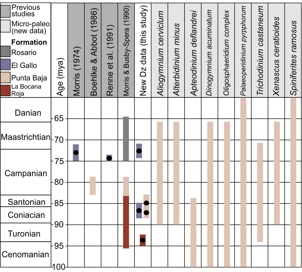
Micropaleontological and palynological samples from the Punta Baja Fm. were analyzed to compare with detrital zircon MDAs. Two samples were collected from the Punta Baja Fm. for palynology analysis to complement existing micropaleontology data (Boehlke & Abbott, 1986). Samples were processed in a standard fashion (Wood et al., 1996). Residues were analyzed for their organic matter content and identification of key dinoflagellate cyst species (Table 2; Supplementary Materials). Species were compared with published age ranges from the region in order to determine an acme age range.
STRUCTURAL AND STRATIGRAPHIC FEATURES: OBSERVATIONS
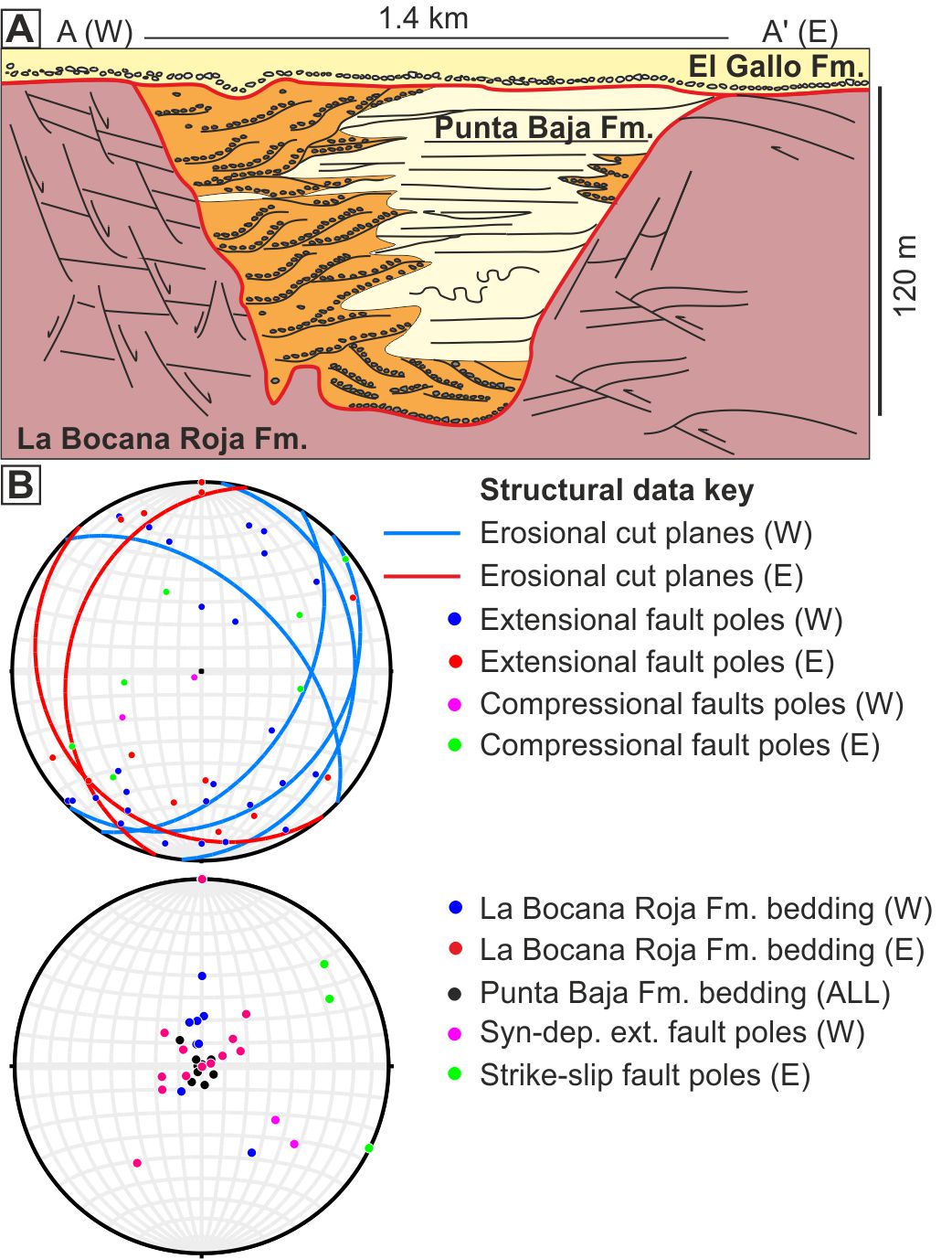
Mapping and stratigraphic correlation indicates that the canyon fill trends NNE-SSW, with paleoflow to the SSW (Fig. 1 & 2; Boehlke & Abbott, 1986). The canyon’s basal erosion surface is exposed along its western margin, where coarse-grained canyon axis facies directly onlap the bedrock. Here, the canyon margin is characterized by localized canyon-base incisions spatially associated with normal faults, superimposed on the major canyon cut (Figs. 2–5). Towards the east, coarse-grained canyon facies transition laterally to finer-grained canyon terrace and internal levee facies, which onlap the bedrock (La Bocana Roja Fm., Boehlke & Abbott, 1986) (Fig. 2). The bedrock is more structurally deformed than younger units (Figs. 2, 3), with a high degree of variability in bedding orientation. Overall, the bedrock forms a broad SW-plunging syncline, with shallow bedding dips predominantly south-southeast on the western side of the canyon fill and towards the southwest at up 18° on the eastern side (Fig. 1). This fold structure is incised and onlapped by the Punta Baja Fm., which dips at 1–8°, with local dip changes in the Punta Baja Fm., related to the underlying bedrock structure (Fig. 1). The overlying, sub-horizontal, El Gallo Fm. displays an angular discordance with the Punta Baja Fm. and beyond the canyon-cut rests unconformably on the La Bocana Roja Fm. A locally discontinuous but aerially extensive cobble lag with well-rounded Gastrochaenolites (bored) clasts occurs at the base of the El Gallo Fm.
_equal_area_stereonets_presenting.jpg)
_measured_se.jpg)
Several sets of faults affect the bedrock, and to a lesser extent the canyon fill (Figs. 2B, 4). On the western side of the canyon, post-depositional extensional faults dominate within the bedrock and generally strike WNW-ESE, and are downthrown to the south (Fig. 2). A subset of NNE-SSW striking extensional faults in bedrock share the same orientation as syn-depositional faults in the Punta Baja Fm. (Fig. 2). On the eastern side of the canyon, contractional faults dominate, with N-S to NW-SE orientations, overall eastward shortening, and several WNW-ESE and ENE-WSW trending strike-slip faults (Fig. 2B), recognized by offset strata with minimal vertical displacement but thickness changes, and slickensides, indicating a lateral component of movement. Several fold structures on the eastern side are incised and overlain by low angle bedding within the bedrock. Erosional cuts at the base of the submarine canyon fill, into the bedrock, strike approximately NNE-SSW, dipping towards the SE in the western outcrops, and towards the W-SW in the eastern outcrops, defining a trend that is consistent with the main paleoflow of the canyon (Figs. 1, 2).
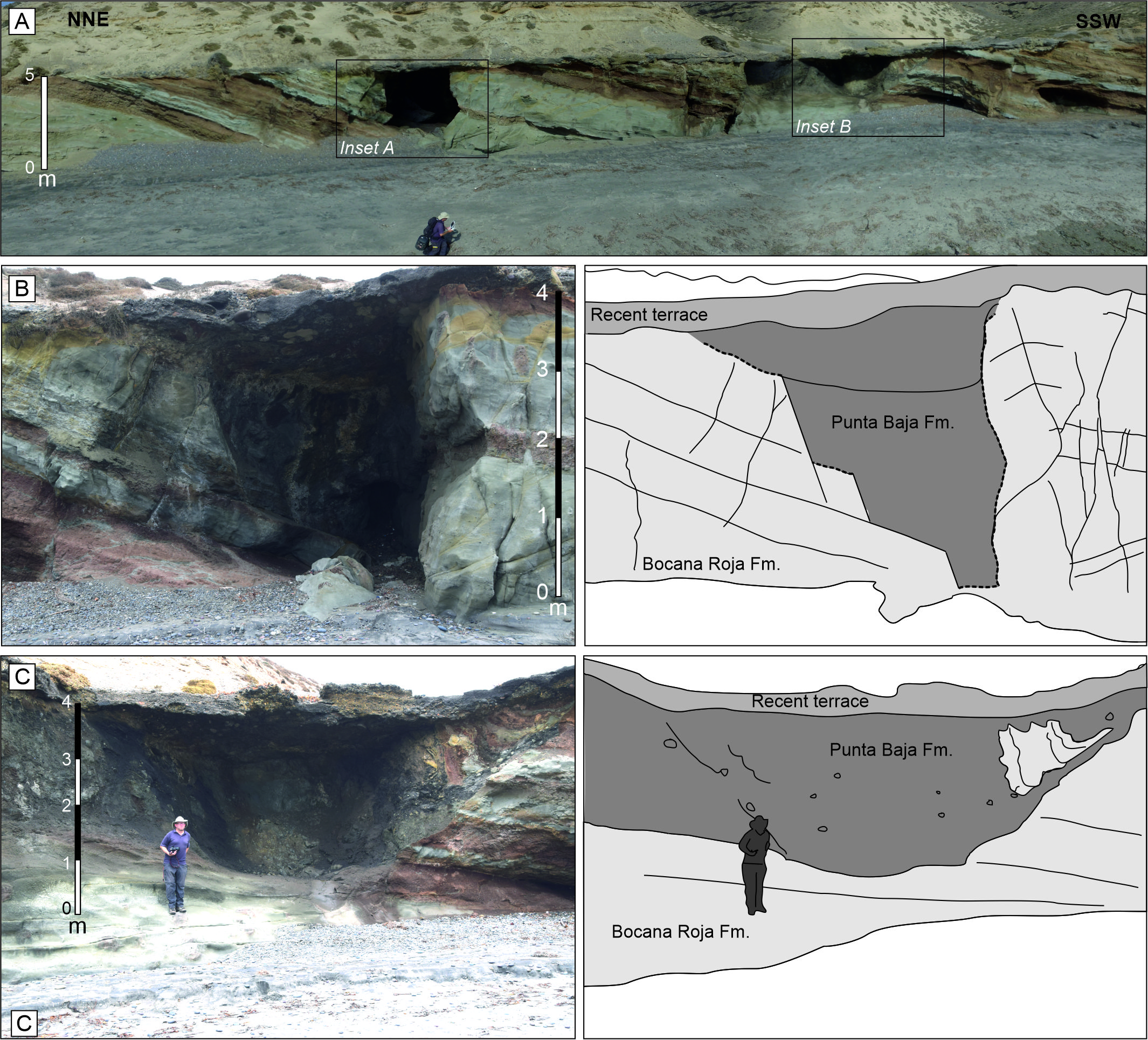
_incisions_into_the_bedrock_(la_bocana_roja_fm.)_focused_on_small_normal_faults_on_the_west.jpg)
_oblique_exposure_of_an_incision_into_the_la_bocana_roja_bedrock._b)_steep_onlap_of_the_ca.jpg)
INTERPRETATION
The La Bocana Roja Fm. bedrock underwent extension and contraction associated with strike-slip displacement during and following deposition, which we attribute to releasing and restraining bends on a dextral strike-slip fault zone oriented approximately WNW-ESE (Fig. 2). Canyon orientation follows the axial plane of the SW-plunging syncline developed within the bedrock. Faults superimposed on this syncline may have acted as planes of weakness, and/or formed seabed topography that localized canyon incision. Observations match the regional study of Busby et al. (1998), who suggested that the La Bocana Roja Fm. was folded and dissected by high-angle reverse faults prior to deposition of the Punta Baja Fm. Deformation was interpreted to be associated with normal faults with a dextral slip component that facilitated the high rate of subsidence (600 m/my) required to accommodate the Upper Cretaceous to Palaeogene stratigraphy (Busby et al., 1998). Above the submarine canyon fill deposits, the basal surface of the El Gallo Fm. is interpreted to rest on a ravinement surface which is locally overlain by a transgressive lag deposit
DEPOSITIONAL ARCHITECTURE AND PALEOGEOGRAPHY OF THE CANYON FILL
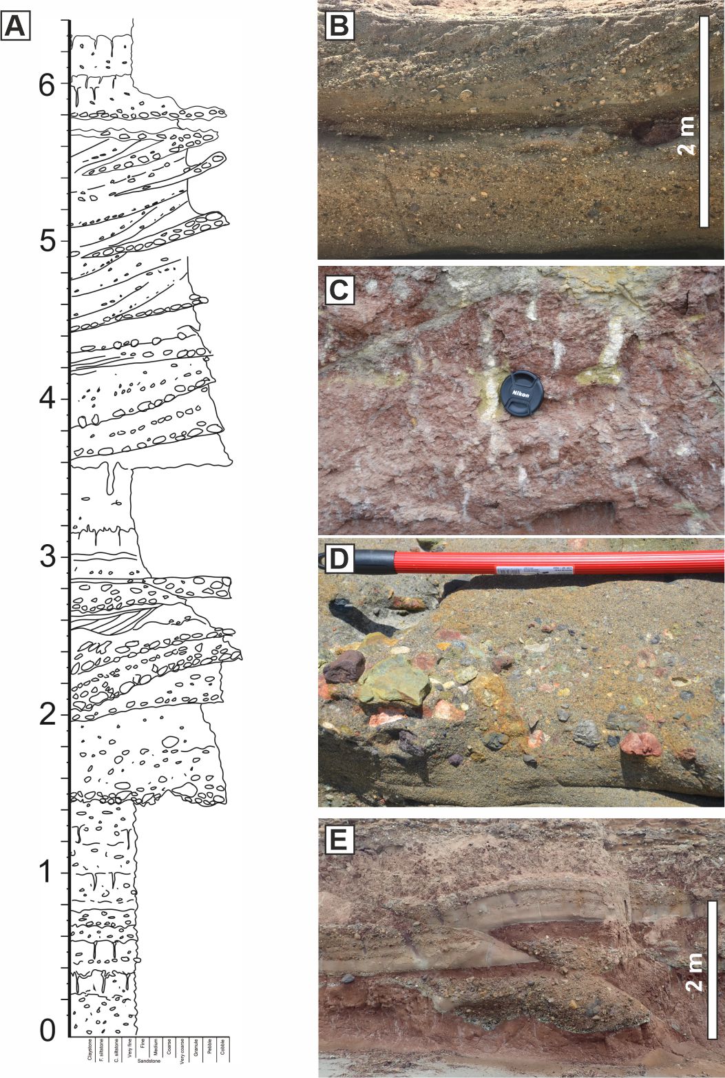
The canyon-fill is c. 120 m thick, 1.2 km wide and has two broad domains; a coarse-grained channelized domain that onlaps the western margin and represents the paleoflow axis, and a fine grained overbank section to the east (Fig. 2A; Boehlke & Abbott, 1986; W. R. Morris & Busby, 1996). Lenticular and wedge-shaped sandstone bodies, which pass eastward into a thin-bedded turbidite succession, characterize the transition between the two domains and are interpreted to represent overbank channels and scour fills. Rugose basal channel erosion surfaces are overlain by debrites with megaclasts (up to several meters across) and thin-bedded turbidite mudstones and sandstones (Fig. 3). Preferential stacking of channel axes in the western side of the canyon may be a response to dominant extensional faulting and subsidence of bedrock on that side and away from contractional features on the eastern side, or may alternatively reflect an autocyclic control on stacking of component channel-fill (e.g., Hodgson et al., 2011), or an interplay of the two.
Micropaleontology and palynology
Sample BOC-1 from within the coarse-grained western channel fill was barren of palynomorphs, being dominated by oxidized and degraded wood fragments. Sample PBI-1, collected from within the fine grained, thin-bedded turbidites of the eastern side demonstrated a wide range of plant fragments, marine detritus and an abundance of palynomorphs, including dinoflagellate cysts. The ratio of marine (67.5% n=139) to non-marine (32.5% n=67) palynomorphs indicates proximity to a landmass, but is dominantly marine, whilst the ratio of Perinoid (45% n=57) to Gonyaulacoid (55% n=69) dinocysts indicates lower productivity conditions, potentially with a stratified water column, and lacking significant upwelling (Pross & Brinkhuis, 2005).
An abundance of open marine dinoflagellate cysts, e.g., Spiniferites sp., supports deposition of the Punta Baja Fm. canyon sediments in the outer neritic zone, typical of a shelf edge setting (Table 2; Fig. 6). The dominance of gonyaulacoid over perinoid cysts suggests a relatively stratified, lower productivity water column, and the ratio of marine organisms to terrestrial pollen and spores demonstrates proximity to land but an overall marine setting (DR2).
_pbi-1_dominated_by_degraded_wood_fragments_with_palynomorp.jpg)
Depositional Ages
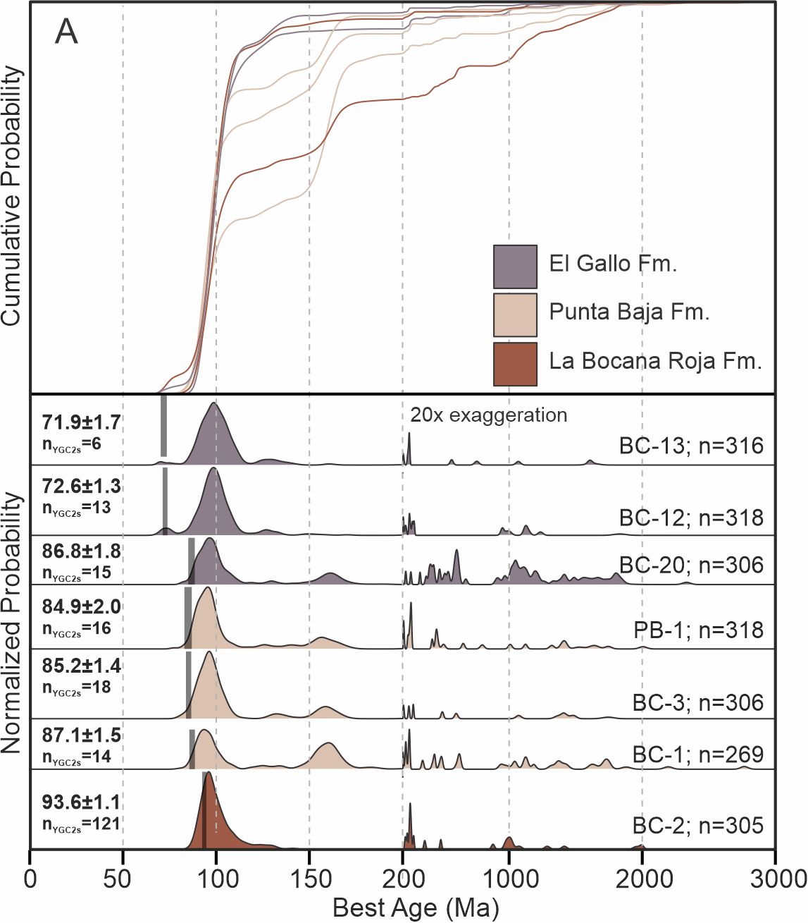
Cumulative and normalized probability density functions for all samples together with MDAs calculated using the YGC 2σ method of Dickinson and Gehrels (2009) are presented for the eight samples analyzed (see methods section; Fig. 8; Table 3). While there is no systematic up-section change in the data presented, the oldest and youngest samples are missing the 150 Ma peak seen in all the Punta Baja samples and the older El Gallo sample, suggesting that rivers were tapping a different source at that time. Samples BC-1 and BC-20 have comparably diverse and slightly more abundant ages >200 Ma than the other samples, also suggesting hinterland drainage changes. The new data yield an MDA for the La Bocana Roja Fm. of 93.6±1.1 Ma (Turonian). Previous work suggested a Campanian age, based largely on the presence of a theropod dinosaur fossil, Labocania (Molnar, 1974). The Punta Baja Fm. MDAs range from 87.1±1.5 Ma in the axis to 84.9±2.0 Ma at the base of the overbank section. Dinoflagellete cysts are abundant in the muddy parts of the canyon-fill, and our analysis (Table 2) suggests a Coniacian to Santonian age, with Apeteodinium deflandrei having a last known occurrence in the Santonian; together the two datasets support a probable Coniacian age for the canyon fill. This is considerably older than the Early Campanian age suggested by Boehlke & Abbott (1986) based upon the presence of the calcareous nannofossil Calculites ovalis, which is now known to first appear in the Coniacian (Burnett, 1998), so its presence is not inconsistent with our MDAs. The upper middle Campanian age given by Glycymerita veatchii bivalves in the Punta Baja Fm. (Squires, 2010) is based on their general increase in size from the Turonian onwards, so their large size in the Punta Baja Fm. may be related to localized environmental factors.

_cumulative_and_normalized_probability_density_functions_for_all_samples._mdas_were_calcula.jpg)

Immediately above the contact with La Bocana Roja Fm., the El Gallo Fm. yields an MDA of 86.8±1.8 Ma, while MDAs from stratigraphically higher El Gallo Fm. samples yield MDAs of 72.6±1.3 and 71.9±1.7 Ma. Previous 40Ar/39Ar analyses of individual sanidine grains from four El Gallo Fm. tuffs yielded Late Campanian ages of 74.87±0.05 Ma to 73.59±0.09 Ma (Renne et al., 1991), while overlying tuffs were dated at 74.706±0.028 Ma (Fastovsky et al., 2020) and 73±2 Ma (W. J. Morris, 1974). The close replication of the previous younger ages supports the robustness of our method, and therefore the older MDA. However, it is possible that older recycled zircons were analyzed. Nonetheless, our data suggest that the El Gallo Fm. may span a considerably longer time period than previously estimated, which given its thickness (1.3 km), and deposition by multiple sedimentary systems in different shallow-marine to terrestrial environments over evolving fault blocks (W. R. Morris & Busby, 1996), is unsurprising.
DISCUSSION AND CONCLUSION
Uncertainty in the timing of onset and termination of oblique convergence in the Late Cretaceous of the Peninsular Ranges forearc basins has hindered accurate paleogeographic reconstructions, and the constraining of plate motions relative to the Pacific plate (Busby et al., 1998; Kimbrough et al., 2001). La Bocana Roja Fm. strata experienced both syn- and post-depositional contractional and extensional deformation during the Cenomanian-Turonian. At this time, a major pulse of coarse grained material was delivered to the forearc; this has been attributed to the intrusion of voluminous tonalite-granodiorite magmas, with associated erosional topography (Kimbrough et al., 2001), or to an accelerated phase of compression with related contractional deformation from 105–95 Ma (Busby et al., 1998). Kimbrough et al. (2001) suggest that widespread compressional strain ended at 99 Ma, predating the major intrusive episode. Our field-data support ongoing compression during and after La Bocana Roja deposition, but we revise the age considerably from Campanian to Turonian (93.6±1.1 Ma); this was largely over by the onset of canyon filling (87.1±1.5 Ma). Canyon bedrock records oblique contractional deformation with a resulting plunging syncline, and preferential development of extensional faults within its western limb, and contractional topography on the east. We attribute the close association of extensional and contractional domains to releasing and restraining bends on a dextral strike-slip fault zone oriented approximately WNW-ESE that persisted until Late Turonian-Early Coniacian times. These tectonic features appear to have focused sediment gravity flows and canyon incision. Smaller-scale incisions superimposed on the major canyon cut are spatially associated with extensional faults in the bedrock. The canyon was initially a major conduit for sediment bypass to the Pacific Ocean, but the infill became strongly aggradational, suggesting high sediment supply rates and continual development of accommodation through subsidence.
Maximum depositional ages (MDAs) from detrital zircons date the upper part of the fluvial bedrock (La Bocana Roja Fm.) at 93.6±1.1 Ma (Cenomanian-Turonian), the Punta Baja Fm. canyon-fill at 87.1±1.5 Ma to 84.9±2.0 Ma (Coniacian to Santonian), and the overlying El Gallo Fm. at 86.8±1.8 Ma to 71.9±1.7 Ma (Coniacian to Maastrichtian, although the uncertainty overlaps with that of the Punta Baja Fm. suggesting a probable maximum age of Santonian). The timing of the submarine canyon-fill is supported by micropaleontological evidence, which also suggests an uppermost Turonian to Santonian age. Thus, the canyon was cut, filled, buried, uplifted and rotated basinward, planed off through wave ravinement, and onlapped by shallow-marine deposits within an 8 Myr period. The duration of canyon cutting and filling is likely much shorter, but is beneath the resolution of detrital zircon maximum depositional ages (Coutts et al., 2019) and the results demonstrate the relatively short lifespan of major submarine canyons in tectonically active settings (cf. Englert et al., 2018). Plutonic intrusions approx. 100 km to the NE of the study area have been dated at 97+4/-1 Ma (Ortega-Rivera et al., 1997) and 96±4 Ma (Measures, 1996), slightly predating the La Bocana Roja Fm. sediment flux (93.6±1.1 Ma), supporting the role of magmatic emplacement in the generation of erosional topography at this time.
We show that partly syn-depositional oblique contractional deformation of the bedrock influenced canyon incision. However, the canyon fill is not affected by syn-depositional compression suggesting the end of oblique dextral contractional deformation, on this part of the Pacific margin, occurred in the Turonian-Coniacian, significantly later than previously suggested (cf. Kimbrough et al., 2001). Back-dating of the La Bocana Roja bedrock suggests that plutonic intrusions and associated erosional topography to the NE formed likely sediment sources at this time (Kimbrough et al., 2001). Later uplift and basinward tilting of the canyon fill, due to intrabasinal reverse faulting (Busby et al., 1998), occurred in mid-Coniacian times, earlier than previously suggested.
This study provides new insights into the control that antecedent tectonic seabed topography may exert on submarine canyon formation and evolution, and documents the switch from regional extensional to contractional tectonics as recorded in the sedimentary record. Furthermore, the duration of incision and filling of the Punta Baja submarine canyon, and its relationship to structural fabric, has placed new constraints on the timing and style of plate motion relative to the Pacific plate to inform paleogeographic reconstructions.
Acknowledgements
We thank Zane Jobe and an anonymous reviewer for their helpful comments which improved the clarity of the manuscript.